Mining history discovered off the beaten track in Six Mountains
Early prospectors created adits to look for mineral deposits
I’ve written about the exciting, if short-lived, mining history on Mt. Sicker that ended in 1907. https://bit.ly/3mhhzzT
But more mining history awaits those who enjoy randomly wandering through the forests of the Six Mountains.
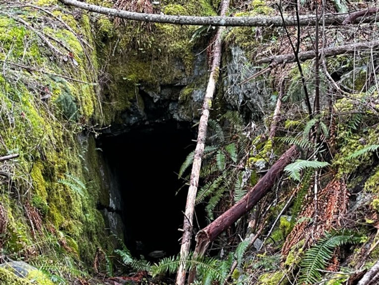
Only a few days ago, I was bushwhacking with a friend down the west side of Mt. Richards when we discovered what appeared to be a tunnel excavated into the mountain side.
Bruce Coates, a geologist and president of the Cowichan Valley Naturalists’ Society, knew right away what it was — a mining adit from the old days of mineral exploration.
Adits are evidence of where prospectors dug out the rock to investigate potentially valuable mineral deposits.
“You can often get a rough idea of how deep the adit goes by looking at the rock removed and dumped at the entrance,” Coates said. “You have to account for the ‘swell factor’ because the blasted rock has a 30 to 40 percent larger volume than the same unblasted rock.”
Adits can come in various sizes; this one on Mt. Richards burrows at least six metres or more horizontally into the mountain side.
We didn’t have a headlamp or gum boots to wade through the pooled water and darkness to investigate further.
It’s hard to say how old these adits are, but Cowichan Valley author and historian T.W. Paterson says they can go way back.

“They were after copper, same as at Mt. Sicker in the years immediately following the shut-down of the Sicker mines,” Paterson says. “There are numerous test holes like this one; none of them became producers.” https://twpaterson.com/
He added: “Smaller operators would have had to rely on sledges and hand drills to create holes for blasting powder or dynamite.”
These adits are not generally marked.
But one is easily accessible near the entrance to Eves Provincial Park in the Westholme area of North Cowichan. Look for the sign that says “cave,” visible as you are exiting the park, next to a parking area for half a dozen vehicles. https://bcparks.ca/eves-park/

While you’re at Eves park, check out the ancient trees next to the creek and a remnant of the old rail line that once delivered ore from Mt. Sicker to the smelter in Crofton.
(Larry Pynn photos: Mt. Richards adit; historian TW Paterson; “cave” sign to Eves park adit)
Subscribe free to sixmountains.ca. More than 29,000 unique visitors.
— Larry Pynn, April 10, 2023
